Tita
BugSat-1 is the first technology demonstration mission for a platform of earth observation satellites. As payload on this mission, some custom designed components will be tested: three antennas, a mid-resolution camera system, a GPS receiver, a UHF radio based on COTS components and a C-Band radio based in COTS components designed for IEEE 802.11a ground operation. The satellite will periodically and autonomously transmitting AX.25 packets for the Amateur radio community to receive in the UHF band, and after the first part of the technology demonstration part of the mission is over, the satellite will enter a mode that will include a Digipeter and science data downloads from the payload for the amateur radio community to use.
NASA-Catalog: 40014
Downlink
437.445 MHz FM 9k6 FSK AX.25
Call
LU7AA
Status
ACTIVE
Orbital Parameter
NORAD                   40014
COSPAR designator       2014-033-E
Inclination             97.993
RA of A. Node           78.187
Eccentricity            0.0033125
Argument of Perigee     304.526
Revs per day            14.91405938
Period                  1h 36m 33s (96.55 min)
Semi-major axis         6 972 km
Perigee x Apogee        570 x 617 km
BStar (drag term)       0.000067340 1/ER
Mean anomaly            55.286
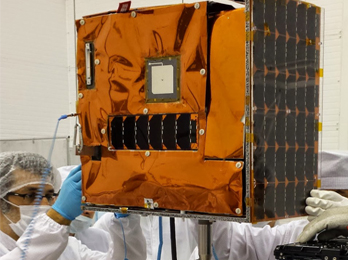
22Kg Microsatellite. 275mm x 500mm x 500mm, with 3 deployable antennas. Stabilized using magnetorquers and reaction wheels. BugSat-1 includes: Avionics, Power generation, distribution and storage, communications and data handling, on board computer and payload. In the payload are included commercial sensors as magnetometers, gyroscopes, light sensors and some custom design parts as a mid-resolution camera. Solar Panels (AzurSpace) on 2 main sides and 3 auxiliary sides; estimated 40W orbital average; 111Wh Li-pol batteries. Main power consuming sections at cruise mode are: OBC (4.48 W) at full power, Communications (780 mW), AOCS (1.6W)
Telemetry
2014-06-20 06:12:41.280 UTC: from LU7AA
000 > C0 00 86 A2 40 40 40 40 60 98 AA 6E 82 82 00 E1 03 F0 FF FF
020 > F0 00 01 00 00 97 58 53 A3 D0 D9 00 00 01 84 08 28 CD 98 01
040 > 01 00 00 66 E0 02 01 00 00 00 00 D7 03 01 00 00 2D 57 03 57
060 > 00 17 03 45 02 14 03 68 01 84 04 01 0C 71 01 2A 05 01 00 00
080 > 00 00 ED 34 11 D8 3A 84 04 4E FF 0D FB 3D FF FF 00 60 00 08
100 > FF E5 00 01 7F 00 00 19 34 00 00 02 2A 00 00 00 00 00 00 00
120 > 00 00 06 01 00 00 00 00 FF FF 00 C0

2014-06-20 06:13:42.380 UTC: from LU7AA
000 > C0 00 86 A2 40 40 40 40 60 98 AA 6E 82 82 00 E1 03 F0 FF FF
020 > F0 00 01 00 00 97 94 53 A3 D1 15 00 00 01 84 08 28 CD 98 01
040 > 01 00 00 66 E0 02 01 00 00 00 00 D7 03 01 00 00 2C DB DC 03
060 > 57 00 16 03 45 01 F6 03 68 01 84 04 01 0C 79 01 38 05 01 00
080 > 00 00 00 C5 5B 0F 13 14 B6 04 A5 FE DD 00 B9 00 05 00 50 00
100 > 0F FF EB 00 01 74 00 00 19 39 00 00 01 BD 00 00 00 00 00 00
120 > 00 00 00 06 01 00 00 00 00 FF FF 00 C0
Links und weitere Informationen
Launch
The liftoff of the 20th Dnepr rocket, took place as scheduled on June 19, 2014, at 19:11:11 UTC from an underground silo facility No. 370/13 in the Dombarosvsky ICBM deployment area in southern Russia. The rocket carried the KazEOSat-2 (DZZ-MRES) remote-sensing satellite for the imaging of the Earth surface, which was built by the European consortium Airbus Defense and Space for the government of Kazakhstan and a cluster of 36 secondary payloads for customers from 17 countries, including Deimos-2, Hodoyoshi-3, Hodoyoshi-4, BugSat-1, SaudiSat-4, AprizeSat-9, AprizeSat-10, UniSat-6, Tigrisat, AeroCube 6, ANTELSAT, Lemur-1, BRITE-CA 1, BRITE-CA 2, NanosatC-Br1, Duchifat-1, Perseus-M1, Perseus-M2, QB50P1, QB50P, Tablesat-Avrora, 11 satellites Flock-1c, POPSAT-HIP 1, PACE, PolyITAN, DTUSat-2.